WHAT CAN WE EXPECT FROM THE FUTURE WATER SITUATION? REVIEW OF RECENT RESULTS UNDER THE CAWA PROJECT OVER 2012-2015
The present water use planning in the Aral Sea Basin is mainly based on the provisions of the General Plans for Integrated Development of Amu Darya and Syr Darya River Basins that were approved by the former Soviet Ministry for Land Reclamation and Water Management. Decisions made by the Interstate Commission for Water Coordination in Central Asia (ICWC) every year essentially follow from the figures indicated in those General Plans, with appropirate adjustments for the current (or forecast) run-off hydrographs and for hydropower generation amounts. Thus, the current river water regimes follow the ‘business as usual’ scenario. However, the ongoing climate change virtually changes this ‘status-quo’ in terms of both future changes in water resources (i.e. quantity of available water) and quantities of water consumption.
The supposed gap between the above values calls for updating of agricultural development scenarios in order to encourage production of less water consuming crops and application of water saving technologies. SIC ICWC by using the information from hydro-meteorological forecasts of the Wurzburg University and GFZ German Research Centre for Geosciences has modeled the future water availability in the Syr Darya River Basin by 2050 using the Fergana Valley as an example. The output of the modeling exercise was presented for choice of future water management policy options in the riparian countries.
Changes in hydrological regime and resources as an effect of climate change
The signed Paris Accord did not ease disputes about certainty of the discussed scales of global warming and its effects. Currently every country is guided by temperature trends of their regional forecasts. As to hydrological forecasts, the figures of probable changes vary greatly here, especially in part of extremes, variations of which are much larger than those of average annual values.
The forecast of the natural run-off in the Naryn River made by German researchers using the WASA/REMO 0406 model shows a gradual downward trend for a period from 2020 to 2050, with the maximum lowering, against the average for 2020–2025, by 12% over 2030–2035. Moreover, in general, as compared to the base period of 2001-2010, the total annual run-off of Naryn and Karadarya Rivers could decrease to 67% of the norm, with the probability of dry years (90% and less) in 47 cases out of 100. The degree of water deficit would be more acute by 15-20% in this dry period compared to the dry years of the base period – 2001 and 2008.
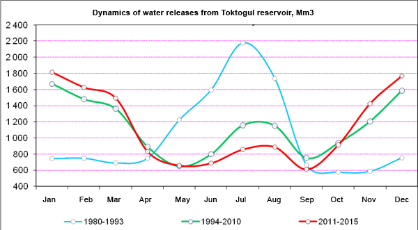
An impact of flow regulation
The operation of the Naryn reservoir cascade with the head Toktogul, Andizhan, and Kairakkum reservoirs has radically altered the natural river flow regime. Before independence, the flow regulation was focused on irrigation needs and then, since the formation of independent states, it has been shifted to energy generation with slight provision of water for irrigation, mainly for Kyrgyzstan’s needs in summer. In the recent five-seven years, the regulation of the Naryn River became stricter in terms of increase of a share of winter water releases as compared to the whole period since 1994, when the initial design operation regime was changed to energy generation.
Consequently, despite lowering of water demand in summer because of expansion of winter wheat areas, the scarcity of water in the middle reaches (Fergana Valley and Hunger Steppe) was constantly more than 2 cubic kilometers during the growing season. Decade (ten-day) deviations in water supply reached 45% in summer months. In case if the strict energy-generation regime of reservoir operation is kept, summer water deficit will increase up to 3.7 km3.
The Project analyzed three probable strategies of irrigated agriculture: business as usual (including preservation of present crop rotation) (BAU); food security and diet change scenario (FSD); and, export-oriented sustainable adaptation scenario with maintenance of the existing irrigated area (ESA). The diagram below shows the unit water inputs per produced agricultural output for the three scenarios by 2050. It is evident that the ESA scenario has advantages over others. In combination with application of drip irrigation and other advanced irrigation techniques, this scenario will help to lessen water deficit by 1.6 km3 by 2050, while the amount of water use will not be higher than that of the year 1990. More attention also should be paid to implementation of IWRM, based on IWRM-Fergana Project lessons. The latter project succeeded in reducing water withdrawals by 200 million cubic meters annually from the Syr Darya River system and, moreover, allowed overcoming the dry year 2008 without any crop damage.
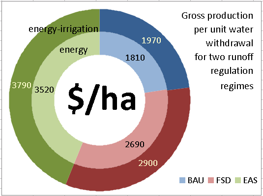
Comparing unit water productivity in three agricultural development scenarios
Improving water use planning
While modeling the amounts and plans of water use under conditions of temperature growth, a hypothesis was made that vegetation phases would become shorter through increased heat quantities (by 19 days for cotton) and evapotranspiration would decrease accordingly. This hypothesis needs field validation.
nformation tool for Central Asia - WUEMOCA
In 2015, the work on the online tool WUEMOCA was started. WUEMoCA is proposed as a tool for assessments of water and land use efficiency and monitoring of crops, based on remote sensing methods. This work is to be completed in 2017 inclusive. In the first year, the focus was on the development of the webportal, surveying of basin organizations in order to identify their needs for RS-based data, development of a base algorithm for land and crop assessments, and synthesis of available historical data in combination with the former Landsat and MODIS images (2000–2014).
The online tool WUEMoCA is designed as an open-source WebGIS, so its surface is available via internet with every current web browser. The client application is written in HTML, CSS and JavaScript, including OpenLayers (for mapping functionalities) and ExtJS (for elements of the Graphical User Interface). The client application, map server, and spatial database will be located on the central webserver. The open-source software GeoServer acts as map server that is the link between client application and spatial database. The data will be stored in PostgreSQL/PostGIS database. All single components are well synchronized and OGC-standard-compliant. The OGC (Open Geospatial Consortium) provides the formats for the data exchange, request, and receipt: Web Map Service (WMS) and Web Map Tile Service (WMTS).
Functions completed in the test mode
The test application, which can be run on a local computer, was developed since January to mid-March 2015. Some elements and functions of the final application version have been already completed and ready for validation:
1. The application window framework with the central map window and the surrounding panels is realised using the “Viewport” element of ExtJS.
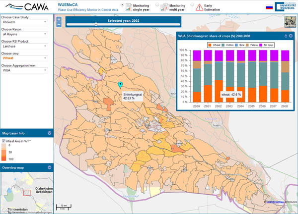
WUEMoCA user interface (preliminary)
2. Data: The test application uses the data on Khorezm region that includes land use and cotton yield aggregated at WUA level. This data was prepared in the past completed Project phases.
Recommendations
1. Develop national strategies for each basin, taking into account the suggested climatic and hydrological scenarios. Revisit agricultural scenarios by placing focus on optimization of cropping patterns in order to achieve maximum irrigation water productivity.
2. Given the coming more frequent and deeper extreme fluctuations of flow, revisit the current water management in basin and provincial water agencies to make it more adaptable to such fluctuations. Regarding major watercourses (Amu Darya and Syr Darya) and their tributaries, an agreement should be reached at the ICWC level for revision of basin management rules in order to ensure multiyear flow regulation and observe primarily energy-irrigation regimes of water releases from reservoirs.
3. Organize wider adoption of water conservation practices as a part of IWRM and transition to advanced irrigation technique, such as drip irrigation, sprinkling, and hose irrigation.
|